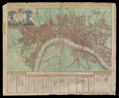
A Plan of the Citys of London, Westminster and Borough of Southwark, with the new Additional Buildings, Anno 1720
Collection: Smith Collection
Name: A Plan of the Citys of London, Westminster and Borough of Southwark, with the new Additional Buildings, Anno 1720
Barcode: 1829
Creator: Parker, S. (Samuel), active 1715-1728Senex, John 1678-1740
Notes: Note lower right: "S. Parker Delin. et Sculpt."From the author's "A New general atlas ... ," published in 1721Indexes points of interest.
Date/Date Range Produced: 1720
Date/Date Range Published: 1720
Language: English
Region Depicted: London, EnglandThames River
Dimensions: H 52 x W 63.3 cm
Printing Process: Engraving
Printing Technique: Copper
Material Type: Paper
LC Call Number: G5754.L7 1720 .S4
OCLC: 35125901
Donor: Smith
Permenant URL: https://oshermaps.org/map/1829.0001