A New Map of New England According to the Latest Observations
Collection: Smith Collection
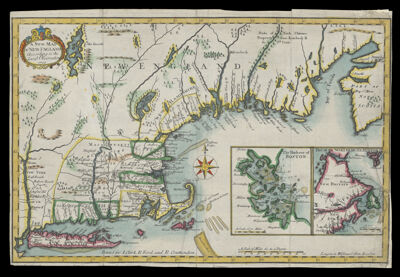
Name: A New Map of New England According to the Latest Observations
Barcode: 1830
Creator: Clark, JamesCruttenden, R.Ford, R.
Notes: Inset maps: "The Harbour of Boston;" "Part of the Northern Hemispheare"Note: "Printed for J. Clark, R. Ford, and R. Cruttenden"Covers also part of New York and Nova Scotia; Differs from other 1720 ed. in that it does not have imprint information above lower neat line.From Daniel Neal's: History of New-England, 1720
Date/Date Range Produced: 1720
Date/Date Range Published: 1720
Language: English
Dimensions: H 24 X W 35.8 cm
Printing Process: Engraving
Printing Technique: Copper
Material Type: Paper
LC Call Number: G3720 1720 .N41
OCLC: 57244900
Donor: Smith
Permenant URL: https://oshermaps.org/map/1830.0001