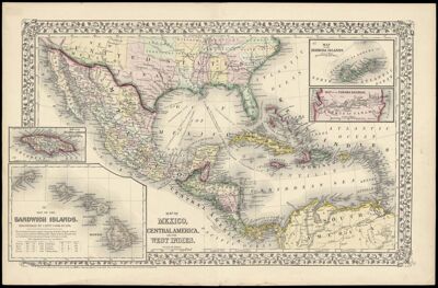
Map of Mexico, Central America, and the West Indies.
Collection: Story Collection
Name: Map of Mexico, Central America, and the West Indies.
Barcode: 2309
Publisher: Mitchell, S. Augustus, Jr. (Samuel Augustus)
Publishing Location: Philadelphia
Notes: Note below neat line: "Entered according to Act of Congress in the year 1870 by S. Augustus Mitchell, Jr. in the Clerks Office of the District Court for the Eastern District in Pennsylvania."
Insets maps: "Map of the Island of Jamaica" "Map of the Sandwich Islands" "Map of the Bermuda Islands" "Map of the Panama Railroad"
Date/Date Range Produced: 1870
Language: English
Region Depicted: Bermuda IslandsCaribbean regionCentral AmericaHawaiian IslandsJamaicaMexicoPanama
Dimensions: 38 x 56
LC Call Number: G4410 .M5 1870
OCLC: 56625770
Accession Number: ST-1870-17
Donor: Story
Permenant URL: https://oshermaps.org/map/2309.0001