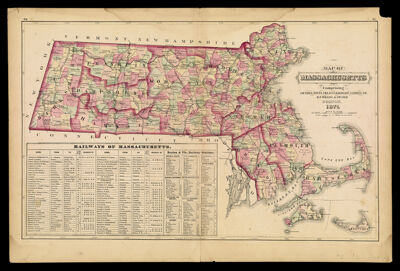
Map of Massachusetts Comprising Counties, Towns, Villages, Railroads, Stations, etc.
Collection: Story Collection
Name: Map of Massachusetts Comprising Counties, Towns, Villages, Railroads, Stations, etc.
Barcode: 4778
Creator: Gray, O. W. (Ormando Wyllis), 1829-1912Walling, Henry Francis, 1825-1888
Date/Date Range Produced: 1871
Language: English
Region Depicted: Massachusetts
Dimensions: 38 x 62
Notes: Notes: "H.F. Walling & O.W. Gray" "Entered according to Act of Congress in the year 1870 by Walling & Gray in the Office of the Librarian of Congress."
Inset table: "Railways of Massachusetts."
LC Call Number: G3764 .W3 1871
OCLC: 57227384
Accession Number: ST-1871-17
Donor: Story
Permenant URL: https://oshermaps.org/map/4778.0001