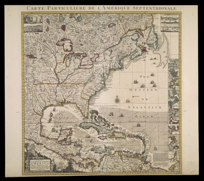
A Map of the British Empire in America with the French, Spanish and Hollandish Settlements adjacent thereto by Henry Popple at Amsterdam Printed for I. Covens and C. Moriter
Collection: Smith Collection
Name: A Map of the British Empire in America with the French, Spanish and Hollandish Settlements adjacent thereto by Henry Popple at Amsterdam Printed for I. Covens and C. Moriter
Barcode: 1861
Creator: Popple, Henry, -1743
From Atlas: No
Publishing Location: Amsterdam
Date/Date Range Produced: 1734 - 1757
Language: English
Region Depicted: CanadaCaribbean regionCentral AmericaNorth AmericaVenezuelaWest Indies
Map Type: Geographical
Dimensions: H 51.4 x W 58.4 cm
Printing Process: Engraving
Printing Technique: Copper
Material Type: Paper
LC Call Number: G3300 .P6 1734
OCLC: 166421471
Donor: Smith
Subjects: AlligatorsAnimalsBirdsCanadaCaribbean AreaCartouches, Ornamental (Decorative arts)Central AmericaClothing and dressColonial AmericaCommerceCovens and MortierIndigenous peopleMonkeysNative AmericansNaval battlesNorth AmericaReptilesSailing shipsVenezuelaWest Indies
Permenant URL: https://oshermaps.org/map/1861.0001