A New and Correct Chart of the Sea Coast of New - England from Cape Codd to Casco Bay. Lately Survey'd by Capt. Henry Barnsley.

Collection: Smith Collection

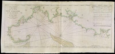
Name: A New and Correct Chart of the Sea Coast of New - England from Cape Codd to Casco Bay. Lately Survey'd by Capt. Henry Barnsley.

Barcode: 1957

Creator: Barnsley, Henry

Date/Date Range Produced: 1763

Date/Date Range Published: 1763

Language: English

Dimensions: 48 x 116

Printing Process: Engraving

Printing Technique: Copper

Material Type: Paper

Notes: Note: "Sold by W. & I. Mount & T. Page on Tower Hill, London" In upper right corner six profiles of landmarks from Agamenticus to Cape Cod From: "The English Pilot" book four

LC Call Number: G3721 .B3 1763

OCLC: 173319113

Accession Number: SM-1763-8

Donor: Smith

Permenant URL: https://oshermaps.org/map/1957.0001