Collection: Osher Collection
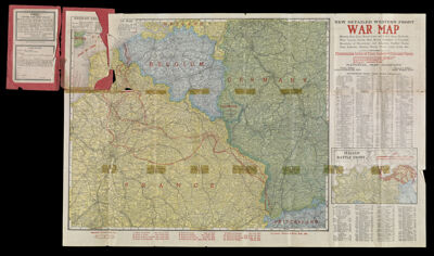
Name: New Detailed Western Front War Map showing main lines, branch lines and narrow gauge railroads, water courses, canals, main roads, boundaries of countries ... with pronouncing index of place names and principal rivers
Barcode:
Notes:
Publisher:
Date/Date Range Produced:
Date/Date Range Published:
Language:
Dimensions: 8279.0001: H 56 x W 86.5 cm
8279.0002: H 56 x W 86.5 cm
8279.0003: H 20.2 x W 12.5 cm
8279.0004: H 20.2 x W 25.2 cm
8279.0005: H 20.2 x W 12.5 cm
LC Call Number:
OCLC: 17790038
Donor:
Subjects:
Permenant URL: