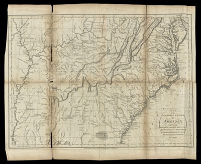
Map of the southern states of America : comprehending Maryland, Virginia, Kentucky, Territory s'th of the Ohio, North Carolina, Tennessee Governm't., South Carolina, & Georgia
Collection: Smith Collection
Name: Map of the southern states of America : comprehending Maryland, Virginia, Kentucky, Territory s'th of the Ohio, North Carolina, Tennessee Governm't., South Carolina, & Georgia
Barcode: 49021
Creator: Russell, John, active 1733-1795Symonds, H. D. (Henry Delahoy)
Notes: Detached from "Maps belonging to W. Winterbotham's History of America" (1804)
Date/Date Range Produced: 1795
Date/Date Range Published: 1795
Region Depicted: GeorgiaKentuckyMarylandNorth CarolinaOhioSouth CarolinaSouthern StatesTennesseeVirginia
Dimensions: H 42.5 x W 51.6 cm
LC Call Number:
OCLC: 24599379
Donor: Smith
Permenant URL: https://oshermaps.org/map/49021.0001