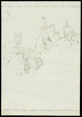
Chart of the Coast Goldsborough to Moose Harbor [Sheet 2 of 3]
Collection: Smith Collection
Name: Chart of the Coast Goldsborough to Moose Harbor [Sheet 2 of 3]
Barcode: 44228
Creator: Des Barres, Joseph F. W. (Joseph Frederick Wallet), 1729-1824
Publishing Location: London
Notes: Note: "Published according to Act, April 24, 1776 by J.F.W. Des Barres, Esqr." From: The Atlantic Neptune. Second sheet of three sheet chart. See also barcodes 4741 and 44229.
Publisher: Des Barres, Joseph F. W. (Joseph Frederick Wallet), 1729-1824
Surveyor: Holland, Samuel, 1728-1801
Date/Date Range Published: Apr 24th, 1776
Language: English
Region Depicted: Maine coastWashington County, Maine
Map Type: GeographicalNautical charts
Dimensions: Chart: 73.5 x 53.5 cm on sheet: 54 x 78.5 cm
Printing Process: Engraving
Printing Technique: Copper
Material Type: Paper
LC Call Number: G3732 .D4 1776
OCLC: 234315415
See Also: A Chart of Delawar Bay.Chart of Coast from Pemaquid Point to Owl's Head Bay [sheet 1 of 2]Chart of Coast from Pemaquid Point to Owl's Head Bay [sheet 2 of 2]Chart of Coast from Pemaquid Point to Owls Head BayChart of Falmouth HarbourChart of Falmouth HarbourChart of Falmouth HarbourChart of Grand Manan IslandChart of Passamaquody BayChart of Penobscot Bay (Upper Part)Chart of the Coast from Burntcoal Island to Skulock PointChart of the Coast from Cape Elizabeth to Musketo IslandChart of the Coast from Cape Elizabeth to Musketo Island Chart of the Coast from Musketo Island to Skuttock PointChart of the Coast Goldsborough to Moose Harbor [Sheet 2 of 3]Chart of the Coast Goldsborough to Moose Harbor [Sheet 3 of 3]Chart of the Coast Goldsborough to Moose Harbor. [Sheet 1 of 3]Chart of the Coast Goldsborough to Moose HarbourChart of the Coast of GeorgiaChart of the Entrance into Penobscot BayChart of the Entrance into Penobscot BayChart of the Harbours and Rivers between Portland Point and Stage IslandChart of the Harbours and Rivers between Portland Point and Stage IslandCharts of the Coast and Harbors of New England [...] [Title page]Coast from Newbury to Cape ElizabethFalmouth Harbor Portland Sound [facsimile]Notes Biographical and Bibliographical on The Atlantic NeptuneNotes Biographical and Bibliographical on The Atlantic Neptune [Front cover]The Coast of New England.Views: (I) Mechios River near the Mills. (II) A Sketch of Mechios Mills[Boston Harbor Chart Des Barres] [facsimile][Coast of Maine - from Spurwink River to Moose Point] [or, from Musketo Island to Cape Elizabeth, including Kennebec River] [facsimile][Coast of Maine - Two Views of Wolves Islands at Entrance of Passamaquoddy Bay][Coast of Maine]
Donor: Smith
Subjects: American Revolution, 1775-1783Maine--MapsMaps--Early works to 1800
Permenant URL: https://oshermaps.org/map/44228.0001