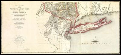
A Chorographical Map of the Province of New-York in North America, Divided into Counties, Manors, Patents and Townships; Exhibiting likewise all the private Grants of Land made and located in that Province; Compiled from Actual Surveys deposited in the Patent Office at New York, by order of His Excellency Major General William Tryon, by Claude Joseph Sauthier, Esqr. Engraved and published by William Faden
Collection: Smith Collection
Name: A Chorographical Map of the Province of New-York in North America, Divided into Counties, Manors, Patents and Townships; Exhibiting likewise all the private Grants of Land made and located in that Province; Compiled from Actual Surveys deposited in the Patent Office at New York, by order of His Excellency Major General William Tryon, by Claude Joseph Sauthier, Esqr. Engraved and published by William Faden
Barcode: 46521
Creator: Faden, William, 1749-1836Sauthier, Claude Joseph
Date/Date Range Produced: 1779
Date/Date Range Published: 1779
Language: English
Notes: Originally hand colored;" Scale of English statue miles about 69 1/2 to a degree. ";"Inscribed: To His Excellency Major General William Tryon ..";" Advertisement. The tracts of land coloured red, are military grants ... Those with a green edge are manors, and those coloured yellow are townships ... "
OCLC: 55153720
Accession Number: SM-1779-5.3
Donor: Smith
Permenant URL: https://oshermaps.org/map/46521.0001; 46521.0002