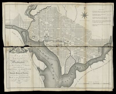
Plan of the City of Washington, in the Territory of Columbia, ceded by the States of Virginia and Maryland to the United States of America, and by them established as the Seat of their Government, after the Year 1800.
Collection: Smith Collection
Name: Plan of the City of Washington, in the Territory of Columbia, ceded by the States of Virginia and Maryland to the United States of America, and by them established as the Seat of their Government, after the Year 1800.
Barcode: 49015
Creator: Russell, John, active 1733-1795
Notes: Shows block numbers and proposed government buildings. Detached from "Maps belonging to W. Winterbotham's History of America" (1804)
Date/Date Range Produced: 1800
Date/Date Range Published: 1800
Language: English
Region Depicted: MarylandVirginiaWashington D.C.
Dimensions: H 43.3 x W 53.2 cm
Printing Process: Engraving
Printing Technique: Copper
LC Call Number:
OCLC:
Permenant URL: https://oshermaps.org/map/49015.0001