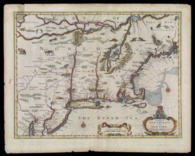
A Map of New England and New York
Collection: Smith Collection
Name: A Map of New England and New York
Barcode: 1765
Creator: Speed, John, 1552?-1629
Printmaker: Lamb, Francis
From Atlas: Yes
Notes: Note: "Sold by Tho: Bassett in Fleet Street, and Richard Chiswell in St. Pauls Church yard." Note: "F. Lamb Sculp". Verso: Descriptions of New England and New York
Publisher: Speed, John, 1552?-1629
Purveyor: Bassett, ThomasChiswell, Richard, 1639-1711
Date/Date Range Produced: 1676
Date/Date Range Published: 1676
Language: English
Region Depicted: CanadaConnecticutDelawareMaineMarylandMassachusettsMiddle Atlantic StatesNew EnglandNew HampshireNew JerseyNew York (State)PennsylvaniaRhode IslandVermont
Map Type: Geographical
Dimensions: H 44.6 x W 55.8 cm
Printing Process: Engraving
Printing Technique: Copper
Material Type: Paper
LC Call Number: G3722 .S6 1676
OCLC: 124069408
Donor: Smith
Subjects: AnimalsBearsBeaversBirdsCanadaCartouches, Ornamental (Decorative arts)Colonial AmericaConnecticutDeerDelawareDevices (Heraldry)FoxesHeraldryLamb, Francis (active 1670 -1700)MaineMaritime ProvincesMarylandMassachusettsMiddle Atlantic StatesNew EnglandNew HampshireNew JerseyNew York (State)PennsylvaniaRhode IslandVermontWeasels
Permenant URL: https://oshermaps.org/map/1765.0001; 1765.0002