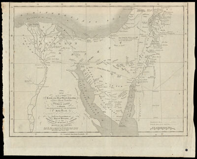
Map of the Countries South of the Dead Sea & Palestine together with the Peninsula of Mount Sinai to Illustrate the journeyings of the Israelites In the Desert by Edward Robinson, Professor Extraordinary of Sacred Literature in the Theological Seminary at Andover, Massachusetts.
Collection: Story Collection
Name: Map of the Countries South of the Dead Sea & Palestine together with the Peninsula of Mount Sinai to Illustrate the journeyings of the Israelites In the Desert by Edward Robinson, Professor Extraordinary of Sacred Literature in the Theological Seminary at Andover, Massachusetts.
Barcode: 2276
Creator: Robinson, Edward
From Atlas: No
Notes: Note below title: "From the Map accompanying Burckhardts Travels. London 1822. Corrected by Ruppel's Chart, Frankfort, 1829. and by Ehrenbergs Map, Berlin 1828."
Date/Date Range Produced: 1829
Date/Date Range Published: 1829
Language: English
Region Depicted: EgyptHoly LandIsraelJordanPalestineSinai Peninsula
Map Type: Historical mapsThematic maps
Dimensions: 21 x 28 cm.
Material Type: Paper
LC Call Number: G7481.2 .R6 1829
OCLC: 57045656
Accession Number: ST-1829-9
Donor: Story
Subjects: Bible --GeographyBurckhardt, John Lewis, 1784-1817EgyptIsraelJordanPalestineRobinson, Edward, 1794-1863Sinai (Egypt)
Permenant URL: https://oshermaps.org/map/2276.0001