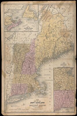
Map of New England or Eastern States Engraved to Illustrate Mitchell's School and Family Geography
Collection: Story Collection
Name: Map of New England or Eastern States Engraved to Illustrate Mitchell's School and Family Geography
Barcode: 2282
Creator: Mitchell, S. Augustus (Samuel Augustus), 1792-1868
Publishing Location: Philadelphia
Notes: Notes below neat line: "Entered according to Act of Congress in the year 1844, by S. Augustus Mitchell, in the Clerk's office of the District Court of the eastern district of Pennsylvania." "Drawn and Engraved by J.H. Young"
At head of title: "No. 8"
Inset maps: "Vicinity of Boston and Providence" "Vicinity of New Haven and Hartford" "New Brunswick Nova Scotia and Newfoundland &c"
Date/Date Range Produced: 1844
Language: English
Region Depicted: Boston, MassachusettsConnecticutMaineMassachusettsNew EnglandNew HampshireNew Haven, ConnecticutNewfoundland and LabradorNova ScotiaRhode IslandVermont
Dimensions: 44 x 29
Printing Technique: Planar Surface
Material Type: Paper
LC Call Number: G3720 .M5 1844
OCLC: 55943998
Accession Number: ST-1844-13
Donor: Story
Permenant URL: https://oshermaps.org/map/2282.0001