Map of Hillboro Co., New Hampshire from actual surveys by J.Chace Jr.
Collection: Textile Museum Collection
Name: Map of Hillboro Co., New Hampshire from actual surveys by J.Chace Jr.
Barcode: 50988
Creator: Anonymous / Unknown Author
From Atlas: No
Publishing Location: Boston (Mass.)
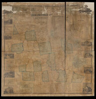
Notes: Illustrations around border: Merchant's Exchange; House of Reformation, Manchester; Court House at Amherst; High School, Milford; City Hall, Nashua; Pearl Street House, Nashua; Main Street, Nashua; Residence & Tannery of J.B. Moulton, North Weare; Appleton Academy, New Ipswich; Smyth's Block & View of Elm Street, Manchester; Masonic Temple, Manchester
Contains Insets: Hancock Center; Parkers; Weare Center; New Boston; Peterboro; Oil Mill Village; Greenfield; Amherst; South Antrim; Piscataquog; Refos Ferry; City of Manchester; Hillsboro Bridge; Bedford Center; Bennington; Goffstown Center; City of Nashua; Factory Village; Mason Village; Bakerville; Hallville; Milford; Hollis; Brookline; Amoskeag; New Ipswich; Mount Vernon; Thornton's Ferry; East Wilton; North Weare; East Weare; Francestown; Goffstown
Includes business directories, information about agriculture, education and religion, and distances between towns
Publisher: Smith, Mason & Co.
Surveyor: Chace, J.
Date/Date Range Published: 1858
Language: English
Region Depicted: New Hampshire
Map Type: City mapsWall maps
Dimensions: 148 x 144 cm
LC Call Number: G3743.H4 1858.C5
OCLC: 39382751
Accession Number: ATH-1858-75
Donor: American Textile History Museum
Subjects: CensusHistoric buildingsNew Hampshire
Permenant URL: https://oshermaps.org/map/50988.0001