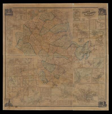
A Topographical map of Essex County, Massachusetts based upon the trigonometrical survey of the state the details from actual surveys under the direction of H.F. Walling.
Collection: Textile Museum Collection
Name: A Topographical map of Essex County, Massachusetts based upon the trigonometrical survey of the state the details from actual surveys under the direction of H.F. Walling.
Barcode: 50989
Creator: Anonymous / Unknown Author
Printmaker: Array
From Atlas: No
Publishing Location: Boston (Mass.)
Notes: Images around border: City Hall, Newburyport. Daguerreotype by L. Bent, 62 State Street, Newburyport; Court House, Salem. From a photograph by D.A. Clifford, 241 Essex Street, Salem; City Hall, Lawrence. From Daguerreotype by A. Hall, no. 8 City Block, Lawrence; Andover Theological Seminar. From Daguerreotype by A. Hall, no. 8 City Block, Lawrence
Insets included: Amesbury and Salisbury Mills; Webster's Point; Newburypoint; East Salisbury; Ipswich; Gloucester Harbor Village; Annis Squam Village; Rockport Village; Pigeon Cove Village; Manchester Village; Essex Village; Hamilton; Marblehead; Beverly; Salem and South Danvers; Beverly Farms; Lanes Ville; Wenham; Lynn and Swampscott; East Saugus; Danvers; West Boxford; East Boxford; Topsfield; West Newbury; Saugus Center; Nahant; Lynnfield; Middleton; Frye Village; Ballardvale; Andover Village; Lawrence; Lynnfield Center; North Beverly; Byfield; North Andover; Sutton's Mills; Methuen; Rowley; Georgetown; South Groveland; Groveland; West Amesbury; Haverhill; Geographic Map of Essex County, Massachusetts; Rocks Village; River Village Amesbury.
Contains business directory, table of distances between towns, census statistics, and data on agriculture, education and religion.
Surveyor: Walling, Henry Francis, 1825-1888
Date/Date Range Published: 1856
Language: English
Region Depicted: Essex County, Massachusetts
Map Type: City mapsTopographical mapsWall maps
Dimensions: 152 x 149 cm
LC Call Number: G3763.E7 1856 W3
OCLC: 1032335446
Accession Number: ATH-1856-49
Donor: American Textile History Museum
Subjects: CensusEssex County (Mass.)Historic buildingsMassachusettsMassachusetts Bay (Mass.)Topographic maps
Permenant URL: https://oshermaps.org/map/50989.0001