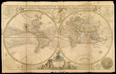
A New and Correct Map of the World laid down according to the newest discoveries, and from the most exact observations by Herman Moll, Geographer
Collection: Smith Collection
Name: A New and Correct Map of the World laid down according to the newest discoveries, and from the most exact observations by Herman Moll, Geographer
Barcode: 4712
Creator: Bowles, Thomas, -1767Moll, Herman, 1654 -1732Sayer, Robert, 1725-1794
Date/Date Range Produced: 1709
Date/Date Range Published: 1709
Language: English
Dimensions: 47 x 95 cm. on sheet 63 x 101 cm.
Notes: Shows the world as a double hemisphere, annual winds and wind directions, solar equinox and ecliptic, and noted corrections over previous geography. Uses unidentified azimuthal projection.
Note: "Printed for J. Bowles & Son at the Black Horse in Cornhill & by T. Bowles map & print seller next to ye Chapter house in St. Paul's Church yard, and by R. Sayer map & print seller near St. Dunstan's Church Fleet Street and by John King at ye Globe in ye poultry." Dedication: "To His Most Sacred Majesty George II by the grace of God King of Great Britain France & Ireland Defender of the Faith &c. this map is humbly dedicated. "
Insets: The Ptolemean Systeme; The North Pole; The Copernican Systeme; Mercury; The Appearance of the Sun; Venus; Mars; Saturn; Jupiter; The Appearance of the Moon.
LC Call Number: G3200.S5 M65 1709
OCLC: 47044466
Accession Number: SM-1709-2
Donor: Smith
Permenant URL: https://oshermaps.org/map/4712.0001