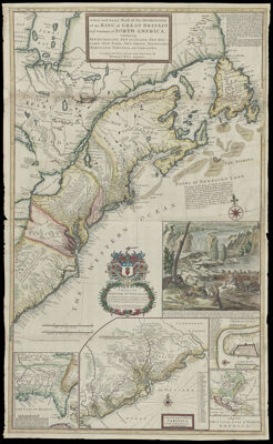
A New and Exact Map of the Dominions of the King of Great Britain on ye continent of North America : containing Newfoundland, New Scotland, New England, New York, New Jersey, Pensilvania, Maryland, Virginia and Carolina ...
Collection: Smith Collection
Name: A New and Exact Map of the Dominions of the King of Great Britain on ye continent of North America : containing Newfoundland, New Scotland, New England, New York, New Jersey, Pensilvania, Maryland, Virginia and Carolina ...
Barcode: 4716
Creator: Moll, Herman, 1654 -1732
From Atlas: No
Notes: Dedicated to Walter Dowglass who governed the Leeward Islands.
Publisher: Moll, Herman, 1654 -1732
Date/Date Range Produced: 1715
Date/Date Range Published: 1715
Language: English
Region Depicted: DelawareEastern CanadaMaineMarylandMassachusettsMiddle Atlantic StatesNew EnglandNew HampshireNew JerseyNew York (State)Newfoundland and LabradorNorth CarolinaNova ScotiaOntarioPennsylvaniaQuébec, CanadaRhode IslandSouth CarolinaVermontVirginia
Map Type: GeographicalPolitical maps
Dimensions: 100 x 60 cm.
Printing Process: Engraving
Printing Technique: Copper
Material Type: Paper
LC Call Number: G3300 .M6 1715
OCLC: 226392438
Accession Number: SM-1715-6
Donor: Smith
Subjects: AnimalsBeaversCanada, EasternCartouches, Ornamental (Decorative arts)Colonial AmericaCrestsDelawareHeraldryMaineMarylandMassachusettsMiddle Atlantic StatesMoll, Herman, -1732New EnglandNew HampshireNew JerseyNew York (State)Newfoundland and LabradorNorth CarolinaNova Scotia (Canada)OntarioPennsylvaniaQuebec (Province)Rhode IslandSouth CarolinaVermontVirginiaWeapons
Permenant URL: https://oshermaps.org/map/4716.0001