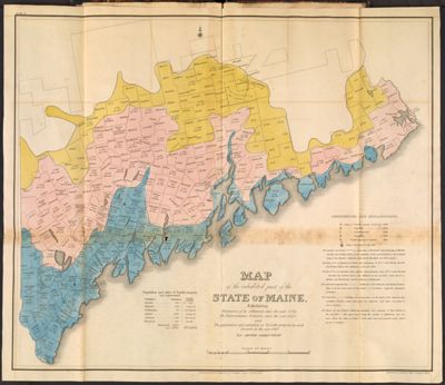
Map of the inhabited part of the state of Maine, Exhibiting - The progress of its settlement since the year 1778. The Representative Districts since the year 1820. and The population and valuation of Taxable property in each district at the year 1820. By Moses Greenleaf.
Collection: Osher Collection
Name: Map of the inhabited part of the state of Maine, Exhibiting - The progress of its settlement since the year 1778. The Representative Districts since the year 1820. and The population and valuation of Taxable property in each district at the year 1820. By Moses Greenleaf.
Barcode: 3564
Creator: Chapin, William, 1802-1888Greenleaf, Moses, 1777-1834Shirley & Hyde
Date Created: 1828
Date Published: 1828
Printing Technique: Copper
Notes: 1828 - inscribed on map
Permenant URL: https://oshermaps.org/map/3564.0007