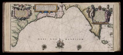
Caarte No. 3 || Chart number 3: Description of the sea coasts of Picardy and Normandy, between Calais and Cap de la Hague and the Channel Islands
Collection: Osher Collection
Name: Caarte No. 3 || Chart number 3: Description of the sea coasts of Picardy and Normandy, between Calais and Cap de la Hague and the Channel Islands
Barcode: 7356
Creator: Blaeu, Willem Janszoon, 1571-1638
Date Created: 1608
Date Published: 1608
Language: Dutch
Region Depicted: Normandy, FrancePicardy, France
Subjects: Normandy (France)Picardy (France)
Permenant URL: https://oshermaps.org/map/7356.0058