Caarte No. 25 || Chart number 25: Sea chart of a part of the Baltic Sea, between Bornholm and Memel (Neman), showing the true location of the coasts of Prussia, Kaszuby, and Pomerania.

Collection: Osher Collection

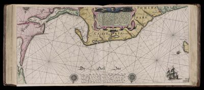
Name: Caarte No. 25 || Chart number 25: Sea chart of a part of the Baltic Sea, between Bornholm and Memel (Neman), showing the true location of the coasts of Prussia, Kaszuby, and Pomerania.

Barcode: 7356

Creator: Blaeu, Willem Janszoon, 1571-1638

Date Created: 1608

Date Published: 1608

Language: Dutch

Region Depicted: Baltic SeaGermany

Subjects: Baltic SeaGermany

Permenant URL: https://oshermaps.org/map/7356.0192