Collection: Osher Map Library Collection
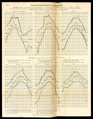
Name: Meteorological Diagrams. Monthly means & extremes of temperature at Brunswick & Williamsburgh in the State of Maine. The continued irregular lines indicate the maximum & minimum temperature observed in the course of each month; the short diagonal lines the means of the months: The dotted lines shew the temperature at Brunswick: the black lines that at Williamsburgh.
Barcode:
Creator:
Date Created:
Date Published:
Notes:
Permenant URL: