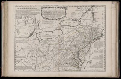
A general Map of the Middle British Colonies in America: viz. Virginia, Maryland, Delaware, Pensilvania, New Jersey, New-York, Connecticut and Rhode-Island: of Aquanishuonigy the Country of the Confederate Indians Comprehending Aquanishuonigy proper, their Places of Residence, Ohio and Thuchsochruntie their Deer Hunting Countries, Couchsachrage and Skaniadarade their Beaver Hunting Countries, Of the Lakes Erie, Ontario and Champlain, Exhibiting the Antient and Present Seats of the Indian Nations...
Collection: Smith Collection
Name: A general Map of the Middle British Colonies in America: viz. Virginia, Maryland, Delaware, Pensilvania, New Jersey, New-York, Connecticut and Rhode-Island: of Aquanishuonigy the Country of the Confederate Indians Comprehending Aquanishuonigy proper, their Places of Residence, Ohio and Thuchsochruntie their Deer Hunting Countries, Couchsachrage and Skaniadarade their Beaver Hunting Countries, Of the Lakes Erie, Ontario and Champlain, Exhibiting the Antient and Present Seats of the Indian Nations...
Barcode: 1986
Creator: Jefferys, Thomas, 1710-1771
Date Published: Jun 15th, 1775
Content: Graphic
Subjects: Native American tribes
Publisher: Robert Sayer and John Bennett (Firm)
Language: English
Region Depicted: ConnecticutDelawareLake ChamplainLake ErieLake OntarioMarylandNew JerseyNew York (State)PennsylvaniaRhode IslandVirginia
Dimensions: Map: H 48 x W 66 cm on sheet: H 55 x W 75 cm
Printing Process: Engraving
Printing Technique: Copper
Permenant URL: https://oshermaps.org/map/1986.0052