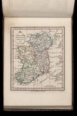
Ireland divided into provinces and counties.
Collection: Smith Collection
Name: Ireland divided into provinces and counties.
Barcode: 4401
Creator: Faden, William, 1749-1836
Date Created: 1798
Date Published: 1798
Language: English
Region Depicted: Connaught Province, IrelandCounty Antrim, IrelandCounty Armagh, IrelandCounty Carlow, IrelandCounty Cavan, IrelandCounty Clare, IrelandCounty Cork, IrelandCounty Donegal, IrelandCounty Down, IrelandCounty Dublin, IrelandCounty Fermanagh, IrelandCounty Galway, IrelandCounty Kerry, IrelandCounty Kildare, IrelandCounty Kilkenny, IrelandCounty Laois, IrelandCounty Leitrim, IrelandCounty Limerick, IrelandCounty Londonderry, IrelandCounty Longford, IrelandCounty Louth, IrelandCounty Mayo, IrelandCounty Meath, IrelandCounty Monaghan, IrelandCounty Offlay, IrelandCounty Roscommon, IrelandCounty Sligo, IrelandCounty Tipperary, IrelandCounty Tyrone, IrelandCounty Waterford, IrelandCounty Westmeath, IrelandCounty Wexford, IrelandCounty Wicklow, IrelandIrelandLeinster Province, IrelandMunster Province, IrelandUlster Province, Ireland
Permenant URL: https://oshermaps.org/map/4401.0061