Collection: Osher Map Library Collection
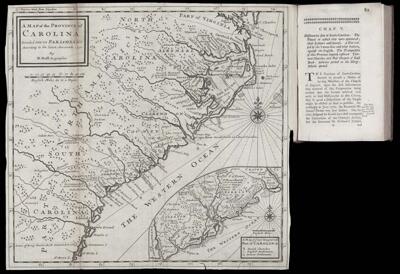
Name: A Map of the Province of Carolina Divided into its Parishes &c. According to the latest Accounts. 1730. By H. Moll Geographer.
Barcode: 50321
Creator: Humphreys, David, 1689-1740Moll, Herman, 1654 -1732
Date Published: 1730
Permenant URL: https://oshermaps.org/map/50321.0066