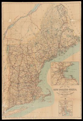
Map of the New England States showing State, County and Town Boundaries
Collection: French Collection
Name: Map of the New England States showing State, County and Town Boundaries
Barcode: 15305
Notes: Oversize map mounted on cardboard.Includes 2 insets: Boston and vicinity; Providence and vicinity.Map shows administrative and political divisions
Publisher: Walker Lith. & Pub. Co.
Date/Date Range Produced: 1909
Date/Date Range Published: 1909
Language: English
Region Depicted: New EnglandQuébec
Dimensions: 103 x 70 cm
LC Call Number:
OCLC: 74717766
Donor: French
Permenant URL: https://oshermaps.org/map/15305.0001