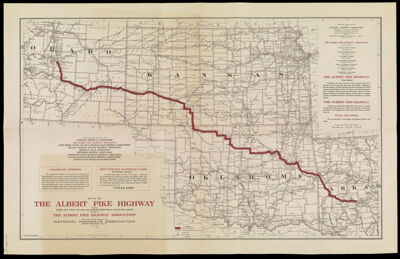
Map of the Albert Pike Highway : showing every city, town, village and hamlet throughout its entire length
Collection: French Collection
Name: Map of the Albert Pike Highway : showing every city, town, village and hamlet throughout its entire length
Barcode: 43168
Publisher: National Highways Association
Date/Date Range Produced: 1919
Date/Date Range Published: 1919
Dimensions: 41 x 46
Notes: Highway goes through the states of Colorado, Kansas, Oklahoma and Arkansas
Includes information about Colorado Springs and Hot Springs National Park in Hot Springs, Arkansas
OCLC: 40246991
Accession Number: FRE-1919-57
Donor: French
Permenant URL: https://oshermaps.org/map/43168.0001