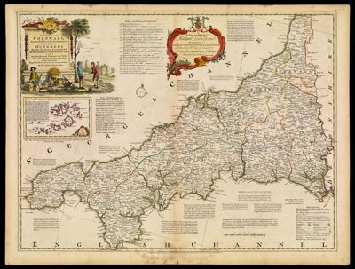
A New Improved Map of Cornwall from the Best Surveys & Intelligences Divided into its Hundreds Shewing the several roads and true Measured Distances between Town & Town also Rectories and Vicarages, the Parks & Seats of the Nobility & Gentry with other useful Particulars Regulated By Astronomical Observations by Thos. Kitchin, Geographer.
Collection: Michie Collection
Name: A New Improved Map of Cornwall from the Best Surveys & Intelligences Divided into its Hundreds Shewing the several roads and true Measured Distances between Town & Town also Rectories and Vicarages, the Parks & Seats of the Nobility & Gentry with other useful Particulars Regulated By Astronomical Observations by Thos. Kitchin, Geographer.
Barcode: 192
Creator: Bowen, Emanuel, 1693 or 1694-1767Bowles, Carington, 1724-1793Bowles, John, 1701-1779Kitchin, Thomas, 1718-1784Sayer, Robert, 1725-1794
Date/Date Range Produced: 1762
Date/Date Range Published: 1762
Language: English
Dimensions: 52 x 69 cm
Printing Process: Engraving
Printing Technique: Copper
Material Type: Paper
Notes: Note: "Printed for Carington Bowles in St. Paul's Church Yard, John Bowles in Cornhil, & Robt. Sayer in Fleet Street."
Dedicated to Richard, Lord Edgecomb
Includes a list of earls and dukes of Cornwall and seats of the nobility and gentry. Also included are descriptions and history of various areas of Cornwall.
LC Call Number: G5754.C8 K5 1762
OCLC: 80017789
Accession Number: MI-1762-11
Permenant URL: https://oshermaps.org/map/192.0001