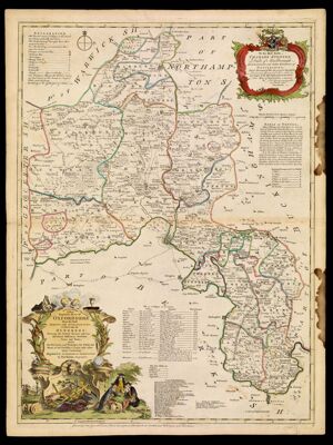
A New Improved Map of Oxfordshire from the Best Surveys and Intelligences, Divided into its Hundreds: Shewing the several Roads and true Measured Distances between Town and Town also the Rectories and Vicarages, the Parks and Seats of the Nobility & Gentry, with other useful Particulars. Regulated by Astronomical Observations by Thos. Kitchin Geographer.
Collection: Michie Collection
Name: A New Improved Map of Oxfordshire from the Best Surveys and Intelligences, Divided into its Hundreds: Shewing the several Roads and true Measured Distances between Town and Town also the Rectories and Vicarages, the Parks and Seats of the Nobility & Gentry, with other useful Particulars. Regulated by Astronomical Observations by Thos. Kitchin Geographer.
Barcode: 195
Creator: Bowles, Carington, 1724-1793Bowles, John, 1701-1779Kitchin, Thomas, 1718-1784Sayer, Robert, 1725-1794
Date/Date Range Produced: 1762
Date/Date Range Published: 1762
Language: English
Dimensions: 71 x 53 cm
Printing Process: Engraving
Printing Technique: Copper
Material Type: Paper
Notes: Note below neat line: "Printed for Carington Bowles in St. Pauls Yard, John Bowles in Cornhil and Robt. Sayer, in Fleet Street."
Dedicated to Charles Spenser, Duke of Marlborough
LC Call Number: G5753 .K5 1762
OCLC: 180096564
Accession Number: MI-1762-9
Permenant URL: https://oshermaps.org/map/195.0001