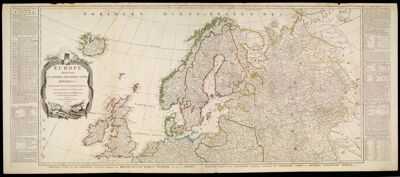
Europe Divided into its Empires, Kingdoms, States, Republics, & ca. by Thos. Kitchin, Hydrographer To the King with many Additions and Improvements from the latest Surveys and Observations.
Collection: Michie Collection
Name: Europe Divided into its Empires, Kingdoms, States, Republics, & ca. by Thos. Kitchin, Hydrographer To the King with many Additions and Improvements from the latest Surveys and Observations.
Barcode: 3246
Creator: Kitchin, Thomas, 1718-1784Sayer, Robert, 1725-1794
Date/Date Range Produced: 1787
Date/Date Range Published: 1787
Language: English
Region Depicted: EuropeNorthern Europe
Dimensions: 2 maps on 4 sheets: 50 x 104 cm. on sheets 54 x 64 cm.
Printing Process: Engraving
Printing Technique: Copper
Material Type: Paper
Notes: Note: "London, Published by Robt. Sayer, Fleet Street, as the Act directs, Jany. 1st 1787."
Western part of the northern states including the British Islands, Norway, Denmark and part of Sweden, Eastern part of the northern states, including the eastern part of Sweden; European Russia, &c., Western part of the Mediterranean Sea with the coasts of Spain, France, Italy, Barbary, Eastern part of the Mediterranean Sea with the coasts of Turky [sic], Anatolia, Syria, Egypt and Barbary.
OCLC: 156999181
Accession Number: MI-1787-1.1
Permenant URL: https://oshermaps.org/map/3246.0001