Europe Divided into its Empires, Kingdoms, States, Republics, & ca.
Collection: Michie Collection
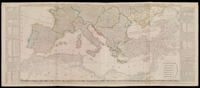
Name: Europe Divided into its Empires, Kingdoms, States, Republics, & ca.
Barcode: 3247
Creator: Kitchin, Thomas, 1718-1784Sayer, Robert, 1725-1794
Notes: Note: "London, Published by Robt. Sayer, Fleet Street, as the Act directs, Jany. 1st 1787."Western part of the northern states including the British Islands, Norway, Denmark and part of Sweden, Eastern part of the northern states, including the eastern part of Sweden; European Russia, &c., Western part of the Mediterranean Sea with the coasts of Spain, France, Italy, Barbary, Eastern part of the Mediterranean Sea with the coasts of Turky [sic], Anatolia, Syria, Egypt and Barbary.
Date/Date Range Produced: 1787
Date/Date Range Published: 1787
Language: English
Region Depicted: EuropeSouthern Europe
Dimensions:
Printing Process: Engraving
Printing Technique: Copper
Material Type: Paper
LC Call Number:
OCLC: 156999181
Permenant URL: https://oshermaps.org/map/3247.0001