Jerusalem qualis (ut plurimum) extitit aetate Solomonis
Collection: Osher Map Library Collection
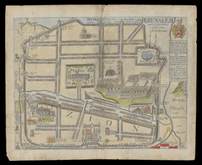
Name: Jerusalem qualis (ut plurimum) extitit aetate Solomonis
Barcode: 12537
Creator: Fuller, Thomas
From Atlas: No
Notes: Later copy of a view published in 1650 in Thomas Fuller's "A Pisgah-Sight of Palestine". The view in the publication is uncolored. Fuller dedicated the view to Edward Montagu, 1st Earl of Sandwich. View depicts what Jerusalem would have looked like during the reign of King Solomon. Dates are between 1650 and 1665.
Dedicatee: Sandwich, Edward Montagu, Earl of, 1625-1672
Date/Date Range Produced: 1665
Date/Date Range Published: 1665
Language: Latin
Region Depicted: Holy LandIsraelPalestine
Map Type: City mapsHistorical mapsViews
Dimensions: 28 x 36 cm.
Material Type: Paper
LC Call Number:
OCLC: 710365792
Subjects: AnimalsAnimals, MythicalAqueductsArmorBethesda, Pool of (Jerusalem)BirdsBullsCourtyardsCrucifixionDiamondsDragonsFountainsGoatsHeraldryHorsesImaginary creaturesIsraelMaps--Early works to 1800PalestineRabbitsSheepStatuesTreesWells
Permenant URL: https://oshermaps.org/map/12537.0001