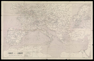
Cook's Map of Europe Showing Principal Railway and Steamship Routes
Collection: Osher Map Library Collection
Name: Cook's Map of Europe Showing Principal Railway and Steamship Routes
Barcode: 12547
Date/Date Range Produced: 1955
Date/Date Range Published: 1955
Language: English
Dimensions: 55 x 88 cm folded to 23 x 15 cm
Notes: Includes text, travel information and advertisements on verso. Also includes inset of Scandinavia.
Note: "Specially prepared by Geographia Ltd."
Shows Thos. Cook and Wagons-Lits offices.
Includes inset of Scandinavia.
Text, travel information, and advertisements on verso.
LC Call Number: G5701.P3 1955 .G4
OCLC: 68816227
Accession Number: OML-1955-36
Permenant URL: https://oshermaps.org/map/12547.0001; 12547.0002