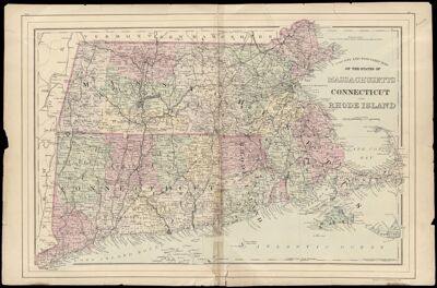
County and Township Map of the States of Massachusetts, Connecticut and Rhode Island
Collection: Morin Collection
Name: County and Township Map of the States of Massachusetts, Connecticut and Rhode Island
Barcode: 12935
Creator: Gamble, W. H. (William H.)
Printmaker: Gamble, W. H. (William H.)
Publisher: Mitchell, S. Augustus, Jr. (Samuel Augustus)
Date/Date Range Produced: 1884
Date/Date Range Published: 1884
Language: English
Notes: Note: "Drawn and engraved by W.H. Gamble Philadelphia"
Note under neat line: "Copyright by S. Augustus Mitchell 1884"
Accession Number: MOR-1884-17
Donor: Morin
Permenant URL: https://oshermaps.org/map/12935.0001