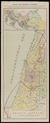
Map of Bible Lands
Collection: Morin Collection
Name: Map of Bible Lands
Barcode: 12950
From Atlas: No
Notes: Created after 1894. Note below the title: "Showing in red line the journeys of Christ and the Apostles while on earth - and showing, also, the journey of Photographic Artist Robert E. M. Bain, in the year 1894 ?".
Publisher: N.D. Thompson Publishing Co.
Date/Date Range Produced: 1895
Date/Date Range Published: 1895
Language: English
Region Depicted: Holy LandIsraelJordanLebanonMiddle EastPalestineSyria
Map Type: GeographicalHistorical mapsPolitical maps
Dimensions: 69 x 28 cm. folds into 18 x 10 cm.
Material Type: Paper
LC Call Number:
OCLC:
Accession Number: MOR-1895-111
Donor: Morin
Subjects: Arab countriesBain, Robert E. M. (Robert Edward Mather), 1858-1932Bible --GeographyChristianityIsraelJordanLebanonMiddle EastPalestineReligionSyria
Permenant URL: https://oshermaps.org/map/12950.0001