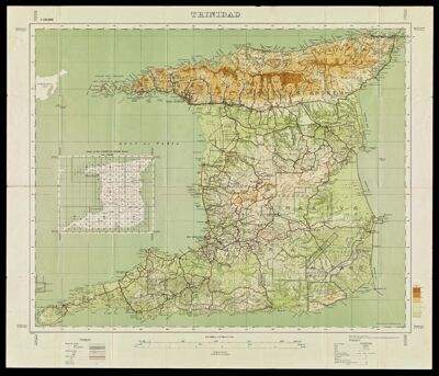
Trinidad Drawn and Heliographed by O.S. 1930
Collection: Osher Map Library Collection
Name: Trinidad Drawn and Heliographed by O.S. 1930
Barcode: 12787
Creator: Government of Trinidad and Tobago
Date/Date Range Produced: 1930
Date/Date Range Published: 1930
Language: English
Dimensions: 63 x 78 cm folded in cover 19 x 12 cm
Notes: Geographical Section, General Staff series, no. 4424
Relief shown by contours, gradient tints, spot heights, and land form drawings.
Insets: Index to the 1:10,000 & 1:50,000 sheets.--Soldado Rock.
LC Call Number: G5150 1930 .G74
OCLC: 5706405
Accession Number: OML-1930-9
Permenant URL: https://oshermaps.org/map/12787.0001