A New Map of Part of the United States of North America, exhibiting the Western Territory, Kentucky, Pennsylvania, Maryland, Virginia &c. Also, the Lakes Superior, Michigan, Huron, Ontario & Erie; with Upper and Lower Canada & c. From the Latest Authorities. By John Cary, Engraver, 1805.

Collection: Howard Collection

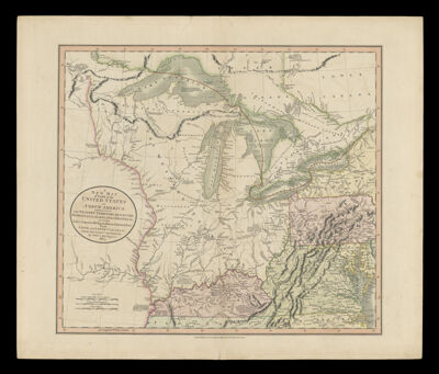
Name: A New Map of Part of the United States of North America, exhibiting the Western Territory, Kentucky, Pennsylvania, Maryland, Virginia &c. Also, the Lakes Superior, Michigan, Huron, Ontario & Erie; with Upper and Lower Canada & c. From the Latest Authorities. By John Cary, Engraver, 1805.

Barcode: 123

Creator: Cary, John

Notes: From Cary's General Atlas London

Date/Date Range Produced: 1805

Date/Date Range Published: 1805

Language: English

Region Depicted: Great Lakes (North America)Great Lakes Region (North America)KentuckyMarylandNew York (State)OhioPennsylvaniaUnited StatesVirginia

Dimensions: H 54.3 X W 64 cm

Printing Process: Engraving

Printing Technique: Copper

Material Type: Paper

LC Call Number:

OCLC: 793035124

Donor: Howard

Permenant URL: https://oshermaps.org/map/123.0001