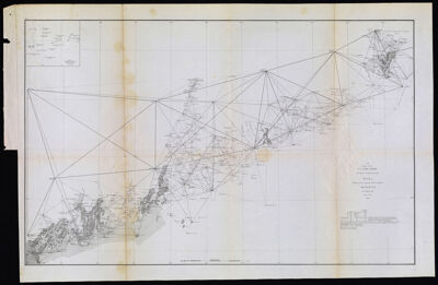
U.S. Coast Survey A. D. Bache Superintendent Sketch A Showing the progress of the Survey in Section No. I From 1852 to 1864
Collection: Howard Collection
Name: U.S. Coast Survey A. D. Bache Superintendent Sketch A Showing the progress of the Survey in Section No. I From 1852 to 1864
Barcode: 1114
Creator: Bache, A. D. (Alexander Dallas), 1806-1867
From Atlas: No
Publishing Location: Washington D.C.
Notes: Chart No. 2. Note above title: "A. bis (Upper Sheet)". Survey of the coast of Maine.
Date/Date Range Produced: 1864
Date/Date Range Published: 1864
Language: English
Region Depicted: Gulf of MaineMaine
Map Type: Nautical charts
Dimensions: 45 cm. x 71 cm. on sheet 50 cm. x 76 cm.
Material Type: Paper
OCLC: 891670159
Accession Number: OS-1864-6
Donor: Howard
Subjects: Bache, A. D. (Alexander Dallas), 1806-1867CoastsIslandsMaineMaine, Gulf ofMaine--MapsNautical chartsUnited States Coast Survey
Permenant URL: https://oshermaps.org/map/1114.0001