Colton's Illustrated and Embellished Steel Plate Map of the World on Mercators Projection
Collection: Osher Map Library Collection
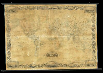
Name: Colton's Illustrated and Embellished Steel Plate Map of the World on Mercators Projection
Barcode: 13124
Creator: Johnson, D. Griffing
From Atlas: No
Publishing Location: New York
Notes: Includes illustrations of cities and people along filigreed border: St. Paul's, London, Southwark Iron and Blacfriars Bridges, The Monument in London; St. Patricks and Presbyterian Churches, St. Charles Hotel in New Orleans; The Landing of Columbus; Winter Palace, The Admiralty, War Office, Statue of Peter the Great, St. Isaac's Church in St. Petersburg; Notre Dame, St. Sulpice, Hotel des Invalides, Palais dei Enilleres, Hotel de Ville in Paris; Swiss woman, Circassian and Greek soldiers; Mandarin and Lady, Chinese Court; Canton; Rome; New Jersey, Hudson River, Castle Garden, Battery, Trinity of St. Pauls, City Hall, Merchant Exchange, Revenue Office, U.S. House, Corlears Hook, East River, Brooklyn in New York; Bay of Naples; Constantinople; Turkish Harem; South American Indians; List of distances to and from various cities around the world at the top of map. An explanation of projection at the top of map. Map is torn; coming apart from rails
Publisher: J.H. Colton & Co.
Date/Date Range Produced: 1855
Date/Date Range Published: 1855
Language: English
Region Depicted: ConstantinopleIstanbul, TurkeyLondon, EnglandNew OrleansParis, FranceParis, FranceRome, ItalyWorld
Map Type: Wall maps
Dimensions: 105 x 125
LC Call Number: G3200 1854 .J6
Accession Number: OML-1855-61
Subjects: Arctic regionsJ.H. Colton & Co.OceansSeasWorld maps
Permenant URL: https://oshermaps.org/map/13124.0001