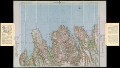
Uppdráttur Íslands: Aðalkort Bl.4, Miðnorðurland
Collection: Howard Collection
Name:
Uppdráttur Íslands: Aðalkort Bl.4, Miðnorðurland
Barcode: 12967
Creator: Geodætisk institut (Denmark)
From Atlas: No
Publishing Location: Copenhagen
Notes: Part of a set of 9 maps covering all of Iceland. Measured in 1914-31. Corrected 1934.
Publisher: Geodætisk institut (Denmark)
Date/Date Range Produced: 1934
Date/Date Range Published: 1934
Language: DanishEnglishIcelandic
Region Depicted: Iceland
Map Type: GeographicalPolitical mapsTopographical maps
Dimensions:
12967.0001: 61 x 107.5 cm
12967.0002: 61 x 84 cm
Printing Process: Offset Printing
Material Type: Paper
LC Call Number:
OCLC:
Donor: Howard
Permenant URL: https://oshermaps.org/map/12967.0001; 12967.0002