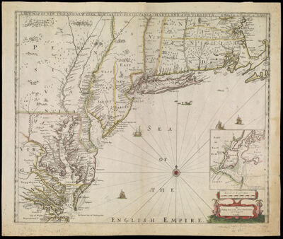
A New Map of New England, New York, New Iarsey, Pensylvania, Maryland, and Virginia. By Philip Lea in Cheap-side London
Collection: Osher Collection
Name: A New Map of New England, New York, New Iarsey, Pensylvania, Maryland, and Virginia. By Philip Lea in Cheap-side London
Barcode: 546
Creator: Lea, Philip, active 1683-1700Morden, Robert, approximately 1650-1703Thornton, John, 1641-1708
From Atlas: No
Notes: Note in bottom right corner: "By Philip Lea at the Atlas and Hercules in Cheap-side London"
Date/Date Range Produced: 1698
Date/Date Range Published: 1698
Language: English
Region Depicted: ConnecticutDelawareMarylandMassachusettsMiddle Atlantic StatesNew EnglandNew JerseyNew York (State)PennsylvaniaRhode IslandVirginia
Map Type: GeographicalNautical chartsPolitical maps
Dimensions: H 49.7 x W 59.2 cm
Printing Process: Engraving
Printing Technique: Copper
Material Type: Paper
LC Call Number:
OCLC: 844377773
Donor: Osher
Subjects: Thornton, John, 1641-1708
Permenant URL: https://oshermaps.org/map/546.0001