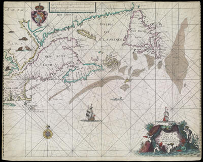
A Chart of the Coast of America from New found Land to Cape Cod by Iohn Seller Hyrographer to the king
Collection: Osher Collection
Name: A Chart of the Coast of America from New found Land to Cape Cod by Iohn Seller Hyrographer to the king
Barcode: 482
Creator: Seller, John, active 1658-1698
From Atlas: Yes
Notes: From: "Atlas Maritimus or the Sea-Atlas being a Book of Maritime Charts." Upper left: coat of arms
Atlas Reference: Atlas Maritimus or the Sea-Atlas being a Book of Maritime Charts
Subjects: Array
Publisher: Seller, John, active 1658-1698
Date/Date Range Produced: 1675
Date/Date Range Published: 1675
Language: English
Region Depicted: CanadaMaineMaritime ProvincesMassachusettsNew EnglandNew HampshireNewfoundland and LabradorNova ScotiaVermont
Map Type: GeographicalNautical chartsPolitical maps
Dimensions: 43 x 54 cm.
Printing Process: Engraving
Printing Technique: Copper
Material Type: Paper
LC Call Number:
OCLC: 456399564
Donor: Osher
Permenant URL: https://oshermaps.org/map/482.0001