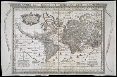
Nova Totius Terrarum Orbis Geographica ac Hydrographica Tabula
Collection: Osher Collection
Name: Nova Totius Terrarum Orbis Geographica ac Hydrographica Tabula
Barcode: 421
Creator: Cavazza, Giovanni Battista, approximately 1620-Visscher, Claes Jansz., 1586 or 1587-1652
From Atlas: No
Publishing Location: Amsterdam
Notes: Originally published by Claes Jansz. Visscher in 1639. Note: "Io. Baptista Cavazza excudebat"
Publisher: Visscher, Claes Jansz., 1586 or 1587-1652
Date/Date Range Produced: 1642
Date/Date Range Published: 1642
Language: Latin
Region Depicted: World
Map Type: GeographicalPolitical maps
Dimensions: H 36.4 x W 56.5 cm
Printing Process: Engraving
Printing Technique: Copper
Material Type: Paper
LC Call Number: G3200 1642 .V5
OCLC: 859160097
Donor: Osher
Subjects: Bow and arrowBustsCanoes and canoeingCartouches, Ornamental (Decorative arts)Cavazza, Giovanni Battista, approximately 1620-Columbus, ChristopherExplorersFlyingfishesFruitGalleonsGiantsImaginary creaturesIndians of South AmericaIndigenous peopleInuitKayaks and kayakingMaps--Early works to 1800ParrotsplantsSailing shipsScrollworkSea monstersVisscher, Claes Jansz., 1586 or 1587-1652Weapons
Permenant URL: https://oshermaps.org/map/421.0001