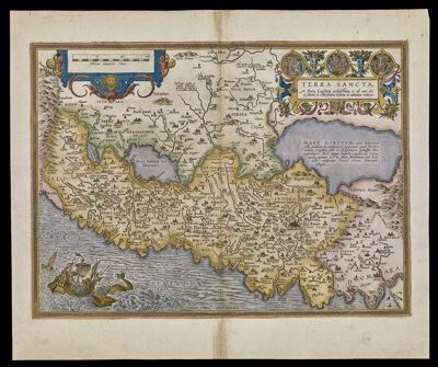
Terra Sancta, A Petro Laicstain perlustrata, et ab eius ore et schedis a Christiano Schrot in tabulum redacta., copy 2
Collection: Osher Collection
Name: Terra Sancta, A Petro Laicstain perlustrata, et ab eius ore et schedis a Christiano Schrot in tabulum redacta., copy 2
Barcode: 340
Creator: Laicksteen, Peter, active approximately 1556-1570Sgrooten, Christian, approximately 1525-1604
From Atlas: Yes
Publishing Location: Antwerp
Notes: This map is from the 1584 Ortelius Theatrum Orbis Terrarum printed in Antwerp by Christopher Plantin, and was the first printing of the map which appears in all editions until 1612. This is Copy 2. Copy 1 is OML-1584-6.
Atlas Reference: Theatrum Orbis Terrarum, 1584
Subjects: Array
Publisher: Plantin, Christophe, appoximately 1520-1589
Date/Date Range Produced: 1584
Date/Date Range Published: 1584
Language: DutchLatin
Region Depicted: Holy LandIsraelMiddle EastPalestine
Map Type: GeographicalPolitical maps
Dimensions: 36 x 50 cm.
Printing Process: Engraving
Printing Technique: Copper
Material Type: Paper
OCLC: 80696384
Accession Number: OS-1584-8
Donor: Osher
Permenant URL: https://oshermaps.org/map/340.0001; 340.0002