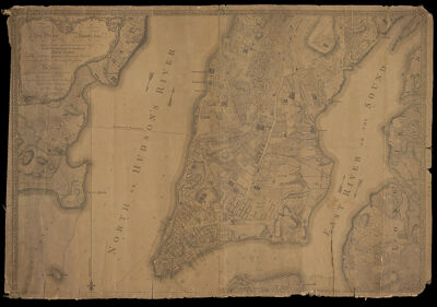
Plan of the City of New York in North America : surveyed in the years 1766 & 1767 B. Ratzer Thos. Kitchin, sculpt
Collection: Smith Collection
Name: Plan of the City of New York in North America : surveyed in the years 1766 & 1767 B. Ratzer Thos. Kitchin, sculpt
Barcode: 4743
Creator: Jefferys & Faden (London, England)Kitchin, Thomas, 1718-1784Ratzer, Bernard
Date/Date Range Produced: 1776
Date/Date Range Published: 1776
Language: English
Dimensions: 101 x 90 cm., on sheet 121 x 90 cm
Notes: Note: "To His Excellency Sr. Henry Moore, Bart., Captain General and Governour in Chief, In & Over His Majesty's Province of New York and the Territories depending thereon in America Chancellor and Vice Admiral of the Same. This Plan, of the City of New York and its Environs, Survey'd and Laid down: Is Most Humbly Dedicated by His Excellency's Most Obed. Humble Servant, B. Ratzer Lieut in His Majestys 60th or Royal American Regt."
"A southwest view of the City of New York, taken from the Governours Island at* "
LC Call Number: G3804.N4 1767 .R3 1776
OCLC: 43490765
Accession Number: SM-1776-21
Donor: Smith
Permenant URL: https://oshermaps.org/map/4743.0001; 4743.0002