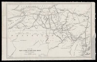
Map of the New York & Erie Rail Road with its Connexions
Collection: Textile Museum Collection
Name: Map of the New York & Erie Rail Road with its Connexions
Barcode: 50630
Creator: Atwood, John M.
Publishing Location: New York
Notes: Note under neat line: "Engraved by J.M. Atwood N.Y."
The New York & Erie Railroad began to extend in 1836 to about 1851. In 1851 the company went into receivership and reorganized into the Erie Railroad.
Date/Date Range Published: 1851
Language: English
Dimensions: H 22 x W 36 cm
LC Call Number: G3801.P3 A8 1851
OCLC: 610059497
Accession Number: ATH-1851-55
Donor: American Textile History Museum
Permenant URL: https://oshermaps.org/map/50630.0001