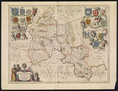
Oxonium Comitatus Vulgo Oxfordshire
Collection: Smith Collection
Name: Oxonium Comitatus Vulgo Oxfordshire
Barcode: 1732
From Atlas: Yes
Publishing Location: Amsterdam
Notes: Verso: description of map in German and Includes an engraved illustration of a megalithic monument.
Date/Date Range Produced: 1649
Date/Date Range Published: 1649
Language: EnglishLatin
Region Depicted: Oxfordshire, England
Map Type: GeographicalPolitical maps
Dimensions: 38 x 49 cm
Printing Process: Engraving
Printing Technique: Copper
Material Type: Paper
LC Call Number: G5753.O8 B5 1649
OCLC: 124069118
Accession Number: SM-1649-4
Donor: Smith
Subjects: All Souls College (University of Oxford)AstrolabesAstronomical instrumentsBalliol College (University of Oxford)Blaeu, Willem Janszoon, 1571-1638Brasenose College (University of Oxford)CalipersCartouches, Ornamental (Decorative arts)Cherubs (Art)Christ Church (University of Oxford)Corpus Christi College (University of Oxford)Cross-staffs (Navigation instruments)Devices (Heraldry)Exeter College (University of Oxford)HeraldryJesus College (University of Oxford)Lincoln College (University of Oxford)Magdalen College (University of Oxford)Merton CollegeNew College (University of Oxford)Oriel College (University of Oxford)Oxfordshire (England)Queens College (University of Oxford)St. John's College (University of Oxford)Trinity College (University of Oxford)Universities and collegesUniversities and collegesUniversity College (University of Oxford)University of Oxford
Permenant URL: https://oshermaps.org/map/1732.0001; 1732.0002