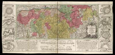
Charte Geographique De La Campagne Du Haut Rhin Pour L'annee MDCCXXXIV Contenant Tous les Mouvemens Marches et Contremarches Des Armes Imperiales et Francoises Comme de Meme Une Designation du Rhine Puis Le Lac || Geographic Map of the Campaign of the Upper Rhine for the year 1734 Containing All the Movement and Steps of the Imperial Weapons and Francoises as the same designation of the Rhine and The Lake
Collection: Smith Collection
Name: Charte Geographique De La Campagne Du Haut Rhin Pour L'annee MDCCXXXIV Contenant Tous les Mouvemens Marches et Contremarches Des Armes Imperiales et Francoises Comme de Meme Une Designation du Rhine Puis Le Lac || Geographic Map of the Campaign of the Upper Rhine for the year 1734 Containing All the Movement and Steps of the Imperial Weapons and Francoises as the same designation of the Rhine and The Lake
Barcode: 14002
Creator: Homann Erben (Firm)Oettinger, Johann FriedrichSeutter, Matthaeus, 1678-1756
Date Created: 1734
Date Published: 1734
Notes: Colored outline and wash. From Atlas Novus. "Oettinger, Johannes, 1577-1633" is LOC's authorized name for a much older mapmaker, but Tooley has two entries for Johannes Freidrich Oettinger, one who is much older and one from the 18th century [6219, the one assigned for this record]. CERL has a "Oetinger, Johannes Friedrich" whose dates of activity was the single year 1778. ULAN lists simply the name "Oetinger".
Permenant URL: https://oshermaps.org/map/14002.0042c