Collection: Morin Collection
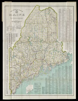
Name: The Official Map of Maine compiled from United States Government Surveys, Official State Surveys, and Original Sources.
Barcode:
Creator:
Publisher:
Publishing Location:
Notes:
Date/Date Range Produced:
Date/Date Range Published:
Language:
Region Depicted:
Dimensions: 115 x 88 cm on sheet 126 x 92 cm
LC Call Number: G3700 .N3 1920
OCLC: 83110880
Accession Number: MOR-1920-34
Donor:
Permenant URL: