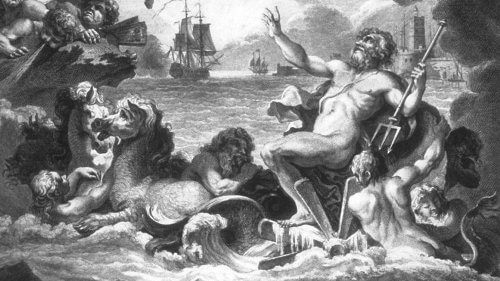
During the great Age of Discovery as mariners began to traverse the Atlantic, and were beyond the sight of land, many fears beset them. They believed that grotesque monsters lay in wait: giant squid would crush their ships in its powerful tentacles, or the raging Kraken of Scandinavian tales smash them with its thrashing spikes and shining horns. But the dangers uppermost in sailor’s minds were the hidden rocks and uncharted reefs, which with seeming malice, lay in wait to destroy their frail vessel. The approach to land was always filled with apprehension, and a careful watch was kept to avoid any peril. Lest they should run aground, depths were determined by tossing a line weighted with lead, forward of the ship. Markings on the line in fathoms (one fathom = six feet) enabled the navigator to know whether or not it was safe to proceed farther on the present course. These soundings were carefully noted and marked on charts to aid to future navigators.
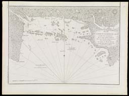
Navigating a safe passage through Casco Bay requires more than the avoidance of its multitude of islands. The greatest dangers are those hidden from view--the rocks and ledges covered by varying depths of water according to the state of the tide. Besides covering and uncovering rocky ledges and a shallow shore, unseen currents produced by the tide can put a vessel off course. To alert the navigator about the possibility of being taken unawares, the set (direction) of tidal currents in Casco Bay are indicated with arrows.
map/2008
Cyprian Southack
English, 1662-1745
M. Sartine
French, fl. 1769-1780
Plan de la Baie et du Havre de Casco
Copper engraving, 41.0cm x 58.1cm
From: Neptune Americo-Septentrional (Paris: Dépôt Général de la Marine, 1779)
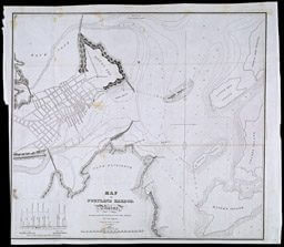
By 1833 sufficient soundings taken in Portland harbor enabled the cartographer of this large-scale chart to create a topographic map of the sea bottom. Isobars--lines connecting equal depth-- give the navigator a comprehensive description of what he will encounter on all routes and points of sailing. As a further aid, the position of buoys are shown, to warn the navigator of danger. Depths are indicated in fathoms at low water. Strong winds, however, can augment or diminish these soundings. A graphic depiction of the effect of wind on the tide is shown in the lower left corner of the chart.
map/983
John Anderson, Lt. Col. U. S. Army Engineer
B. Pool, Lieut U. S. Army Artillery
Map of Portland Harbor . . . 1833
Lithograph,45.8cm x 51cm
From: Report of the Survey of Stanford's Ledge, Portland Harbor, Maine, 1832, Congressional Series 259 (23rdCongress, 1st Session, House Doc. 491) (Washington, DC: Government Printing office, 1834).
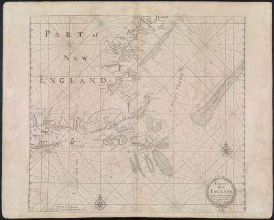
Beyond the coast, far from shore, there are still no assurances that the water is deep and safe for navigation. Whereas at one moment the leadline reveals no soundings, suddenly the sea can shallow, threatening to rent the bottom of any vessel caught unawares. The many dangerous reefs and shoals off the New England coast were carefully delineated by cartographers to prevent such disasters. Henry Hudson, during his 1609 voyage, eager to avoid the already well known Georges Bank was caught on Nantucket Shoals. The force of the current brought him so close to breaking waves on the shoal that he was forced to anchor for two days until a favorable wind and tide enabled him to gain the release of his ship.
map/519.0001
John Thornton
English, 1641-1708
William Fisher
English, fl.1669-1691
Part of New England
Copper engraving, 42.4cm x 47.1cm
From: The English Pilot. The Fourth Book (London, 1689)
In the distant geological past, Georges Bank was part of the mainland, connected to Cape Cod. As the ice-sheet over the land retreated, and the sea level rose to flood low-lying ground, it became an island, and eventually covered--but just barely--with water to become the shoal it is today. Giovanni da Verrazzano, a Florentine navigator, sailed in 1524 under the flag of France in an attempt to find a mid-latitude passage to Cathay. On the homeward passage, he encountered Georges Bank and named it Armelline Shoals (after a villainous papal tax collector). Variously called the Great Rise, and the Great Bank of Malabarre, early English colonists re-named Armelline Shoals after St. George, the patron saint of England. In the days before Loran and satellite navigation, latitude and longitude were determined by celestial navigation. But the fog shrouded region of Georges Bank rarely allowed it. Instead, the mariner had to rely on an intimate knowledge of the character of the ocean floor to gain his bearings. This was attained by filling the small hollow at the bottom of the lead-line weight with tallow or wax. Samples of the seabed stuck to the tallow, and brought to the surface for inspection. Small differences in the composition of the aggregate were telling signs to determine position. By 1832, as testimony to its importance in the fishing industry, virtually every square foot of Georges Bank had been sounded and charted. Charles Wilkes' "Chart of Georges Shoals and Bank," with over 1,000 soundings, and multitude of bottom composition recordings, was so thorough (in the area surveyed) that not until 1930 was a new survey undertaken. The most common tidal current on the coast of Maine is the reversing current. But for much of the Gulf of Maine, and particularly on the offshore banks (such as Georges Bank, shown here), there is another type called rotary currents. Rather than running in a comparatively constant direction for six hours, then a reciprocal direction for another six hours, these rotary currents continually shift their direction every hour. In the northern hemisphere the direction is constantly clockwise. Arrows show the direction of the current, and their length is proportional to the speed as measured against a scale. These rotary currents usuall appear as an irregular ellipse with minor and major axes of flow.
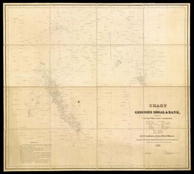
map/998.0001
Charles Wilkes, Lieutenant U. S. Navy, later Rear Admiral
American, 1798-1877
Chart of Georges Shoal & Bank
Copper engraving, 99.1cm x 111.1cm
Washington DC: The Navy Commissioners, 1837